Home / Recent Posts / Activities / Beaches Southern Coast

Best Beaches on the Southern Oregon Coast

Updated: April 18, 2024

The beaches of Bandon, Oregon are some of the best for rockhounding, seen here lined with sea stack rock formations
Face Rock is a sea-stack lined beach in Bandon, Oregon / daveynin, CC-BY-2.0

Starting with the Oregon Dunes in Winchester Bay and stretching all the way down to Brookings near the California border, the beaches on the southern coast of Oregon are some of the best in the state. Most of these beaches are reachable in 3 to 6 hours driving from Portland or 2 to 4 hours from Eugene.

It may take a little longer to get there, but the rewards are worth it. Oregon’s Adventure Coast is quieter, a bit warmer and less traveled than the beaches up north. You may drive 30 miles before you reach the next town, but you’ll be treated to some of the most dramatic scenic views on the entire coast of Oregon.

We’ve compiled a list of the best beaches to visit on the southern Oregon Coast, including popular beaches along with some lesser-known options and most of these beaches are reasonably accessible to the public. The list is in order from north to south.

This page may contain affiliate links where we earn a small commission at no cost to you. As an Amazon Associate, we earn from qualifying purchases. Our suggestions are based on our own experience and thorough research.  Full disclosure.

Why the Oregon Coast is The People's Coast

In 1967, the Oregon Beach Bill declared free public beach access to everyone. Unlike California and Washington, the public has “free and uninterrupted use of the beaches,” in Oregon and all beach areas from the waves to the vegetation line are publicly owned.

Southern Oregon Coast Beaches

Sand dunes at Winchester Bay, Oregon Coast near Reedsport
Sand Dunes at Winchester Bay, Oregon Coast / Rachelle Bender, ODOT

Beaches Near Winchester Bay and Reedsport

Reedsport is the gateway to the Oregon Dunes National Recreation Area, one of the largest expanses of coastal sand dunes in the world, stretching more than 40 miles south from Florence to Coos Bay.

There are several beach access areas in the dunes for off-road vehicle use, plus hiking trails, fishing, paddling, swimming, horseback riding, biking, wildlife viewing, birding, picnicking and camping.

For more information about campgrounds, trails and beach access in this area, see our complete guide to the Oregon Dunes.

Ziolkouski Beach Park is an interesting driftwood-lined beach area in Winchester Bay featuring two jetties that form a triangle sticking out into the ocean. | Map

👉 Find more things to do in Winchester Bay and Reedsport.

Beaches Near Coos Bay

Sun setting at Sunset Bay State Park near Coos Bay Oregon
Sunset Bay State Park near Coos Bay, Oregon / Sheila Sund, CC BY 2.0

Take Cape Arago Highway 540 and visit a string of gorgeous beaches and coastline before the road ends at Cape Arago State Park. Bastendorff Beach, Yoakam Point, Gregory Point and Cape Arago Lighthouse (not open to public), Sunset Bay State Park and Shore Acres State Park can all be accessed from this 5-mile stretch of road ending at the cape. | Map

Interested in more lighthouses? See the best lighthouses on the Oregon Coast.

Seven Devils State Recreation Site features a beautiful stretch of beach south of Cape Arago where you can also access Merchants Beach and Agate Beach | Map

Whiskey Run Beach is a wide section of sandy beach with vehicle access south of Fivemile Point. | Map

👉 Find places to stay and eat plus more fun things to do near Coos Bay.

Essential Beach Safety for the Oregon Coast

The ocean waves in Oregon are very powerful and unpredictable. Please enjoy the beaches safely and follow these guidelines.

  1. Know the tide schedule before visiting the beach so you don’t get trapped by incoming tides. Visit about 1 hour before low tide, as the water is still receding.

  2. Bring a flashlight for exploring tunnels or sea caves.

  3. Wear sturdy footwear. Rocks are often slippery at the beach.

  4. Watch out for sneaker waves on the Oregon Coast. These waves appear out of nowhere and are dangerously fast and powerful. Don’t turn your back to the ocean. 

  5. Rip currents are strong undertows that can sweep you off your feet and pull you out to sea. Admire the ocean from a safe distance or stay in shallow, calm water when wading.

  6. Stay back from cliff edges as erosion can cause the ground to become unstable. Beware of falling rocks, stay behind safety fences, heed warning signs and stay off jetties.

Beaches Near Bandon

Coquille River Lighthouse near Bullards Beach State Park in Bandon at the Oregon Coast
Coquille River Lighthouse, Bandon, Oregon / Bonnie Moreland

Bullards Beach State Park is located 2 miles north of Bandon and features beach trails, horseback riding, camping and the historic Coquille River lighthouse. The lighthouse signal room is open from mid-May through September, but the tower is closed to the public.

Bandon South Jetty Park is just across the river and offers nice views of the lighthouse and ocean.

Bandon is known for its especially scenic, sea-stack lined beaches like Face Rock State Scenic Viewpoint and Bandon Beach, Devil’s Kitchen and Bandon State Natural Area.

Coquille Point and Oregon Islands National Wildlife Refuge are great places to spot birds and sea lions. | Map

👀 You may witness the Circles in the Sand labyrinth art on the beach near Face Rock if you visit in spring and summer (April to August).

👉 Find restaurants, hotels and more fun things to do in Bandon.

Beaches Near Port Orford

Cape Blanco State Park near Port Orford on the southern Oregon Coast
Cape Blanco State Park near Port Orford, southern Oregon Coast / Troy Smith

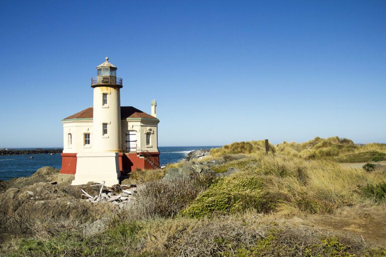
About 10 miles north of the town of Port Orford, Cape Blanco is the westernmost point of Oregon, where the coastline veers out into the Pacific Ocean. Cape Blanco State Park is a must-visit spot on the southern Oregon Coast with miles of hiking trails, scenic ocean viewpoints, fishing, horse trails, a campground and a historic Victorian home.

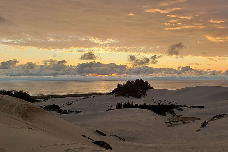
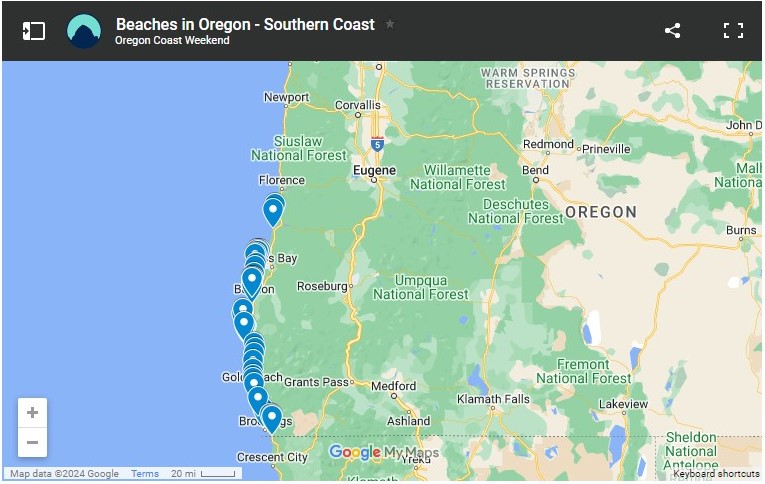
Next to Cape Blanco, on the north side of the Sixes River, Floras Lake State Natural Area is a lesser-known area popular with windsurfers. Here you’ll find hiking trails to Blacklock Point, Floras Lake, Floras Lake Waterfall and the sheer Blacklock Cliffs. There are some impressive beach views and rock formations to see and Boice-Cope Park, a small county campground on the north end of the lake, has overnight campsites. | Map

Battle Rock Wayside Park is a day-use city beach park named after a fierce battle between natives and European settlers in 1851. The visitor center is also located in this park for more information about the surrounding area. | Map

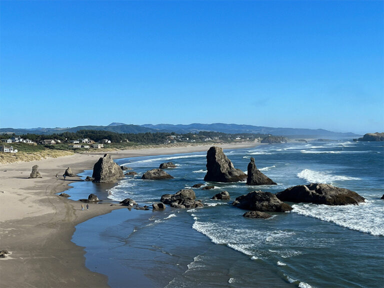
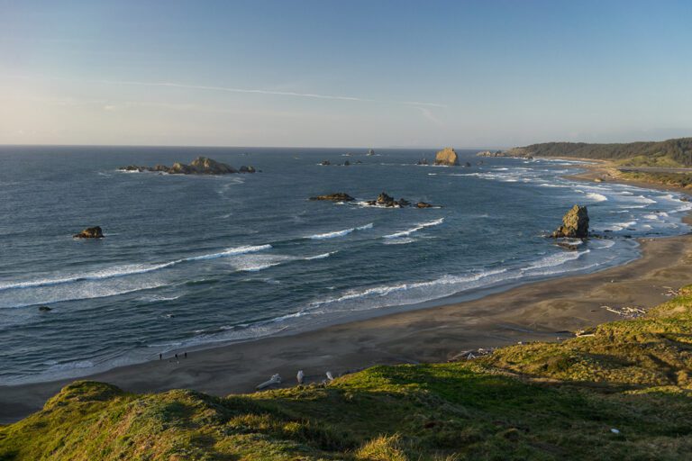
Port Orford Heads State Park offers some of the most impressive views of the large rocks, coves, cliffs and rugged coastline in this area. Explore the hiking trails and the historic Coast Guard lifeboat station and museum.

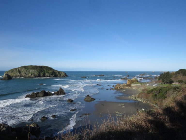
Tseriadun State Recreation Site (pronounced serry-AH-dun) or Agate Beach is a windswept beach lined with small stones perfect for agate hunting. The adjacent Paradise Point State Recreation Site is also good for beachcombing and rockhounding. | Map

👉 Learn more about rockhounding and agate hunting on the Oregon Coast.

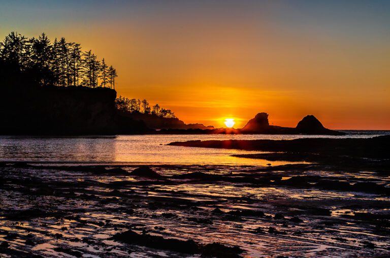
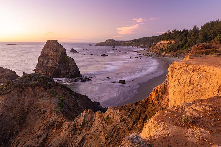
Sisters Rock State Park is a beautiful rocky beach dotted with sea stacks great for hiking, tide pools and sea caves. | Map

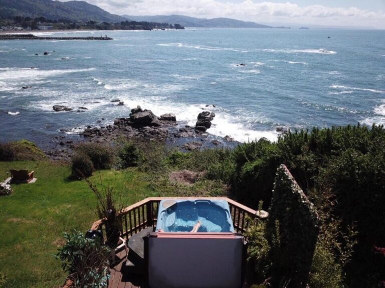
👉 Find places to stay and eat, plus more fun things to do near Port Orford.

Beaches Near the Town of Gold Beach

The rocky coastline at Otter Point State Recreation Site in Gold Beach, Oregon
Otter Point State Recreation Site, Gold Beach, Oregon / Gary Halvorson, OR State Archives

Several uncrowded beaches stretch for miles along the southern Oregon Coast near the town of Gold Beach. Along Highway 101 north of Gold Beach, stop at Ophir Beach and Nesika Beach for wide open, quiet beaches perfect for walks.

Otter Point State Recreation Site offers beach trails and stunning views of the ocean and rock formations. Explore Bailey Beach and Barley Beach.

Driving south from Gold Beach, stop at Kissing Rock for some excellent beachcombing and continue to Cape Sebastian State Scenic Corridor. The Cape Sebastian Trail leads roughly 2 miles each way through coastal forest to amazing views of the coastline.

Just south of Cape Sebastian, pull off at Meyers Creek Beach Viewpoint for a picturesque beach view with rock formations perfect for watching sunsets. | Map

Stop at the Pistol River State Scenic Viewpoint for beach access where the Pistol River meets the ocean and windswept sand dunes. The area is popular with kite boarders and the dunes provide excellent bird watching. | Map

👉 Find hotels, restaurants and more fun things to do near Gold Beach.

Beaches Near Brookings

Harris Beach rock formations in the ocean as seen from the top of a hike on the southern Oregon Coast near Brookings, Oregon
Harris Beach State Park near Brookings, Oregon / OR Parks and Recreation

Just 2 miles north of Brookings, Harris Beach State Park has hiking trails, miles of scenic beach, tide pools and a campground with overnight camping for RVs and tents. Some campsites even have ocean views.

One of the most popular things to do in this part of the southern Oregon Coast is to drive the Samuel H. Boardman State Scenic Corridor. From Brookings, drive north on Highway 101 and you’ll enter the corridor in about 5 minutes.

This 12-mile stretch of U.S. Highway 101 is famous for its natural bridges, sea stacks, arched rock formations and blue-green waters. It is truly an impressive place and should be added to your Oregon bucket list if you haven’t yet experienced it.

There are several marked pullouts along the highway where you can stop and take in some of the most dramatic views of the rocky Oregon shoreline and explore numerous hiking trails including a segment of the Oregon Coast Trail.

👉 For a detailed guide to all of the stops along the Samuel H. Boardman State Scenic Corridor, plus hotels, restaurants and more things to do in the area, see Brookings, Oregon.

South of Brookings, McVay Rock State Recreation Site and Winchuck State Recreation Site offer beach and creek or river access. These are both excellent beaches for rockhounding as well.

Stop at Crissey Field State Recreation Site to visit the Oregon State Welcome Center for free visitor information, maps, brochures and restrooms. This is a great roadside stop and beach for stretching your legs if you’re driving up the Pacific Coast from California.

Find a Beachfront Hotel or Rental on the Southern Oregon Coast

Mermaids Muse Bed and Breakfast in Brookings, Oregon hot tub room with an oceanfront view
Mermaid's Muse Bed and Breakfast hot tub room with an oceanfront view in Brookings / booking.com

After a day of beachcombing, kick back and relax in your oceanfront hotel and enjoy the view.

🛌 From a Star-Trek-themed hotel room in Coos Bay to a bed and breakfast in Brookings with a private cliffside hot tub, see our picks for the best places to stay on the Oregon Coast from north to south. More Hotels»

Map of Beaches on the Southern Oregon Coast

Just click the map of Oregon beaches on the southern coast to get directions from your location.

A map of beaches on the southern Oregon Coast
Map of beaches on the southern Oregon Coast

You may also enjoy:

Enjoy exploring the best beaches on the southern Oregon Coast and feel free to bookmark this page or pin it for future reference to make your beach vacation planning easier.

Follow us:

Scroll to Top